Updated Tuesday July 17,2012
This is a different way to get to Mt. Si and it is a one way trip with a two car shuttle option. The flowers are at their peak now at the top- very unusual flower show!
All photos from Karen Sykes and GPS waypoints from Hiker Bob
Photo below is from Mt. Si looking at Haystack
Check out Green Trails Maps for directions. Map for this week's trip is 206S. Click link below for complete list of maps.http:// http://greentrailsmaps.com/maps/index_Map_wa/
Photo below is on the traverse route close to the Haystack
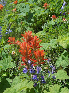
Photo below flowers at the top- Paintbrush
Photo below is view towards North Bend-Rattlesnake and Olympics
Driving directions: From Seattle take I-90 to exit 31 and go north (into town- North Bend). Then at North Bend Way turn right. In less than a mile you'll see the turnoff for Mount Si Road on the left and turn. If you have two cars park one at Mt. Si trail. Then take the other car and drive along Mt. Si road park at the school bus turnaround on your left (this is about 3 miles from North Bend Way). Hike up the logging road. If you have one car park one at school bus turnaround then at the end of the hike you will have a one mile road walk.
Trail stats: Start at GPS waypoint is N 47.48631 W 121.70093 872'. Hike up logging road 4.2 miles and about 3000 foot gain and on left you will find an unmarked old road on your left. This is the traverse section and is on Green Trails Map and GPS waypoint of N 47.50711 W 121.72758 3800'. Continue on this trail another .8 miles can you will be right below Haystack on bench to have lunch. Then hike down is 4 miles. Total if you have a car shuttle is 9.43 miles and 3500 foot gain. That is a workout!! Need Discover Pass to park
Snow Lake an easier hike
If you want an easier hike you can hike towards Snow Lake but just hike to the ridge above the lake. It is 5 miles roundtrip with just a few areas of patchy snow. You can hike to the ridge top above Snow Lake but stop there since the lake is still snow covered with snow and ice on trail down to lake.
To get to Snow Lake trailhead: From Seattle drive east on I-90 to exit 52. Turn left (north), and continue to the end of the road at the Alpental Ski Area parking lot.
Directions are best estimates. Please bring map and compass and or GPS


No comments:
Post a Comment
Note: Only a member of this blog may post a comment.