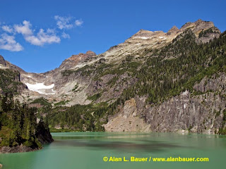
One can call this the hike of the year given the beauty of this lake. One should try to take Monday off 9-15 off of work to enjoy this this sunny hike as there is chance of rain on Tuesday 9-16. However sun should returns (forecast suggesting this) next weekend on 9-20-2014. Thanks to Alan Bauer for the photos.
 |
| Blanca Lake with Columbia Peak |
 |
| Blanca :Lake & Columbia Glacier |
 |
| View of Glacier Peak from ridge top |
Driving Directions: Take US Hwy 2 east from Monroe to just past the town of Skykomish. Turn left on to FR 65, more clearly marked as Beckler River Road, and drive past the Beckler River Campground. Take FR 65 for 15 miles all the way to the intersection of FR 63 and the private Garland Mineral Springs Road. Take a right on FR 63 and proceed about 2 miles. The trailhead is on a small spur road to the left, up another small hill.
Trail Stats: 8.4 miles roundtrip and 3300 gain. Remember you drop about 700 feet to the lake, and you get you climb this steep hill on the way out.
Disclaimer: There are many factors which you should consider in deciding whether to proceed with an outing, including the visible weather at the trailhead, the strength and experience of the party, snow and avalanche conditions, route conditions, etc. You are the final decision maker whether to proceed. West Coast Weather, LLC dba Washington Online Weather cannot be held liable for loss or injury arising from your decision to proceed, and expressly disclaims all liability related thereto. Redmond, Washington USA. Also, please bring map-compass and GPS to help with trail directions as our directions are our best estimate.
 |
| Click to check out our forensic & custom weather services |
No comments:
Post a Comment