Updated: Tuesday April 9, 2013.
.JPG) |
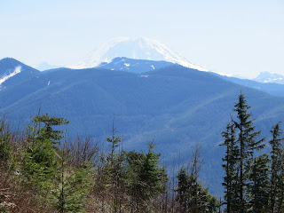
| View of Mt. Rainier from top if weather lets you |
This is a road walk mostly in the forest with views at the top. This is on Washington State DNR land and no snow on road. This is located east of Kent.
Check out Green Trails Maps for list of maps. Sorry no map for this hike. Click
here for complete list of maps.
 |
| Road walk |
 |
| Photo below is Coltsfoot flower starting to bloom |
 |
| Photo below is view towards the north on the way up |
Driving directions: From junction of Highway 18 and and Highway 169 take Highway 169 (Maple valley Highway) south 2.7 miles to Kent-Kangley Road and turn left (east). Then go 6.7 miles on this road. Then park on right next to Blue DNR gated road (do not block gate) and park here. Sign will say: SE Kent-Kangley Road and 346th SE.
Trail stats: 4.1 miles one way elevation gain is about 2500 feet and top is at 3300 feet. Follow main road to the top.
 |
| Park car near here |
 |
Park near this gate this is where you start, photo by Michael Fagin
|
 |
| We took the area marked "gate" the north most entrance and hiked to "radio tower." |
Directions are the best estimates that we have so please bring map and compass and or GPS.
Custom Weather Forecasts Services
 |
Click link above to check out our weather services |
Email us West Coast Weather
Contact us
.JPG)


No comments:
Post a Comment