Wednesday, September 30, 2020

Weather Washington Cascades- Extended Outlook

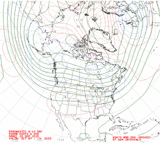
 The extended outlook for next week 10-7 to 10-13 shows a trough of low pressure off our coast (see map below)  at times and we get a zonal flow (from west to east). This will bring above normal temperatures and precipitation.


Map below is 500 mb (18,000') for the period 10-7-2020 to 10-13-2020


Friday, September 25, 2020

Fagin's Hike of the Week- Silver Peak

 I hiked this several years ago but recent trip reports state trail is in good shape. However road has some big potholes in sports. 


View of Mt. Rainier from the top of Silver Peak @ Dennis Long

Below the summit taking a break @ Alan Bauer
Nice fall colors @ Alan Bauer
View of Annette Lake from the top @ Alan Bauer
Driving Directions:

Drive east along I-90 to Exit 54.

At the first intersection (stop sign) located on the west side of I-90, continue straight (south).

On the other side of the intersection, the road becomes known as Hyak Drive East and winds through the Hyak ski area, then passes a waster water facility.

Hyak Drive East becomes Forest Road 9070.

Continue following Forest Road 9070 until its intersection with the Pacific Crest Trail the PCT trail junction occurs approximately 5.5 miles from I-90, in a clear cut area at approximately 3800' elevation. The location of this trail junction is also known as Windy Pass.

Trail stats: 6.5 miles round trip.Hike south along the PCT for approximately 2.0 miles, until a faint trail leading uphill on the right side (west side). The trail junction is unofficially marked, but a large cairn is typically at the location.  Follow the unofficial trail west for approximately 0.6 miles, until reaching a saddle (~4720' elevation) located between Silver Peak and Tinkham Peak.  From the saddle, turn right (north) and follow the trail to and up the south ridge of Silver Peak. The trail traverses through forest and meadows, passing by a minor forested high point (~4900' elevation), before heading up the open talus south ridge of the mountain to the open rocky summit (5605' elevation). Here is the track.

Disclaimer: There are many factors which you should consider in deciding whether to proceed with an outing, including the visible weather at the trailhead, the strength and experience of the party, snow and avalanche conditions, route conditions, etc. You are the final decision maker whether to proceed. West Coast Weather, LLC dba Washington Online Weather cannot be held liable for loss or injury arising from your decision to proceed, and expressly disclaims all liability related thereto. Redmond, Washington USA. Also, please bring map-compass and GPS to help with trail directions as our directions are our best estimate.

Custom Weather Forecasts Services 
Wednesday, September 16, 2020

Fagin's Hike of the Week- Davis Peak

Davis Peak is east of Snoqualmie Pass in the Salmon La Sac area. It offers great views and is a terrific fall hike. Be ready for a work out - 3900 foot gain! Best for views through this Saturday 9-20-2020. I was there several years ago, however I just read a recent trip report that the trail is in good condition. 

Mt. Stuart from the top
Mt. Rainier hiding in the clouds, on the way up
Fire from 13 years ago @ Randy Oakley


Driving Directions: 

From Seattle drive east on I-90 to take exit 80 (signed "Roslyn/Salmon la Sac"). 

Head north on Salmon la Sac Road (State Route 903) about 15 miles, passing through Roslyn and past Cle Elum Lake to Salmon la Sac. 

Go right at the Y to stay on the main road (rather than entering the campground), and in 1.6 miles look for the Davis Peak trailhead and turn left and drive short distance to trail parking.


Trail Stats: 11 miles roundtrip and 3900 foot gain.


Disclaimer: There are many factors which you should consider in deciding whether to proceed with an outing, including the visible weather at the trailhead, the strength and experience of the party, snow and avalanche conditions, route conditions, etc. You are the final decision maker whether to proceed. West Coast Weather, LLC dba Washington Online Weather cannot be held liable for loss or injury arising from your decision to proceed, and expressly disclaims all liability related thereto. Redmond, Washington USA. Also, please bring map-compass and GPS to help with trail directions as our directions are our best estimate.

Click to check out our forensic & custom weather services

Weather Washington Cascades: Extended Outlook

 Starting this weekend and next week forecast models will start to bring in much needed precipitation to our region. This is due to a more zonal (west to east ) wind pattern that brings in moisture from the ocean.

500 mb (18,000') average position from 9-23 to 9-29


Custom Weather Forecasts Services 


Thursday, September 10, 2020

Fagin's Hike of the Week: Hope-Trap-Surprise Lakes Loop

This is a one way hike that starts with dropping one car off at the Surprise Creek Trail head and then driving less than 3 miles to the Tunnel Creek Trail head, which is where you start the hike. 


Trap Lake @Alan Bauer


On the way up to Trap Pass @Alan Bauer


Close to the Pass @Alan Bauer

Trail stats: We have different stats from 12 (map) miles to 10.7 (GPS) and 3000 gain. Track

Driving Directions: 

Drop first car at Surprise Creek Trail: Just past (0.2 miles) Iron Gate Trail (on the left going on east on Hwy 2 turn right. It is just past MP 58 thus about 10 miles past Skykomish. Follow road across the railroad tracks and then turn right and go short distance to trail head. The trail head is about 0.2 miles from Hwy 2 next to the tiny town of Scenic. 

Drop second car at Tunnel Creek Trail: Return to Hwy 2 and go east several miles and turn right onto Forest Road 6095 (not marked). This turn is where Hwy 2 begins  the big sweeping left-hand turn just before the US-2 changes to four lanes and starts the final climb to Stevens Pass. Drive Forest Road 6095 for 1.5 mile, and find trail head on the left: Tunnel Creek Trail head,Trail No. 1061, (3,100 ft).


Disclaimer: There are many factors which you should consider in deciding whether to proceed with an outing, including the visible weather at the trailhead, the strength and experience of the party, snow and avalanche conditions, route conditions, etc. You are the final decision maker whether to proceed. West Coast Weather, LLC dba Washington Online Weather cannot be held liable for loss or injury arising from your decision to proceed, and expressly disclaims all liability related thereto. Redmond, Washington USA. Also, please bring map-compass and GPS to help with trail directions as our directions are our best estimate.

Tuesday, September 8, 2020

Weather Washington Cascades- Extended Outlook

 Most models keep the ridge of high pressure in place till 9-17-2020  although some models suggest the ridge weakens some by 9-14-2020. So lower confidence in the forecast for next week. Models tending towards above normal temperatures and below normal precipitation for today  till 9-17-2020. It will remain warm and dry through at least  9-13 then might have some changes on 9-14  


Map below is the average position for 500 mb (18,000') for the period 9-13 to 9-17


Wednesday, September 2, 2020

Fagin's Hike of the Week- Shriner Peak

 Views of Mt. Rainier, Mt. Adams, Mt St. Helens, and Mt. Hood. That is what you get when you hike to this former lookout at Mt. Rainier Park. Also  no crowded parking lots to fight.  All photos by Alan Bauer.

At the top


Mt. Rainier - Up close


Meadow just below the summit 


Driving Directions:
If you are coming from Enumclaw drive 47 miles on east SR 410 to junction of SR 123 and SR 410.

Go on SR 123 7.5 miles to parking spot on the right.

The trail head is on the other side of the road.

Trail Stats: 3400 foot gain and 8.5 miles roundtrip. Here is our track.  

Disclaimer: There are many factors which you should consider in deciding whether to proceed with an outing, including the visible weather at the trailhead, the strength and experience of the party, snow and avalanche conditions, route conditions, etc. You are the final decision maker whether to proceed. West Coast Weather, LLC dba Washington Online Weather cannot be held liable for loss or injury arising from your decision to proceed, and expressly disclaims all liability related thereto. Redmond, Washington USA. Also, please bring map-compass and GPS to help with trail directions as our directions are our best estimate.

Custom Weather Forecasts Services