Updated October 25, 2017
Hike east of Snoq Pass and this is mostly snowfree now with patchy snow near the river. If one just hikes via the shortcut to the Beacon it is only 4 miles roundtrip and there is no snow. You start trail 1315 and at about one mile in there is a cairn on the left. Go left and then follow this boot-path, it is steep at times. another mile to the beacon.
 |
| Fog layer and Mt. Rainier |
 |
| View of Mt. Rainier from the top |
 |
| The beacon and hikers at top |
 |
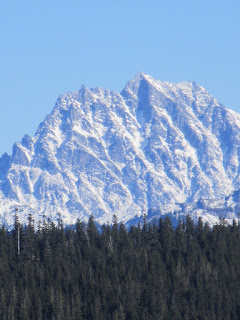
| View of Mt. Stuart after you do the short off trail hike |
 |
| Big Vine Maple on the way up |
 |
| Fall colors on the way up |
 |
| From FS 4818 turn right on an unmarked road with this reflector next to it Waypoint N47.15.976 W121.11.154@ 2260' Please note someone has removed this reflector. |
Directions: From Seattle drive I-90 east and get off at Exit 70. Proceed over the freeway and turn left onto frontage road. Then turn right on FS Road 4818 (signed Kachess Dam Road). Stay on Road No. 4818 go less then one mile to an unsigned road junction, turn right-- on the tree there is a pink reflector (see photo above). Continue about 3/4 mile to the trailhead trail 1315 (Silver Creek) , elevation 2,368 feet (it is also the trailhead for Easton Ridge). Waypoints at Trailhead are N 47.16.03 W 121.10.28
Trail stats: Option 1: Via short cut is 4 miles roundtrip. Option 2. Is not doing the shortcut and use main trail. This is 5.6 miles round-trip with about 2200 feet elevation gain. High point is at about 4584 feet. Hike 1.9 miles on trail 1315 to trail 1315.3 (Waypoint at junction are N 47.17.398 W 121.10.256 at 3743 feet) and to .9 mile hike to top. Thanks to Bob for details. Option 3. Is loop we did with some off trail. Our track is going to Beacon via short cut, then north off trail to viewpoint of Mt. Stuart and backdown via Silver Creek. Close to 7 miles roundtrip.
Custom Weather Services from Weather Experts
 |
Email us West Coast Weather some custom forecasts available for $25 per forecast Contact us
|


No comments:
Post a Comment