Prefect hike rain or shine and you can drive to this trailhead. This is south of Mt. Rainier off Highway 12 near town of Packwood. Thanks to Dennis Long for some of the photos.
 |
| Packwood Lake with Johnson Peak in background @ Dennis Long |
Bring your Green Trails Maps- One of the 10 essentials
 |
| Check out map 302 for this hike |
 |
| Hike in forest canopy stay somewhat dry if rain |
 |
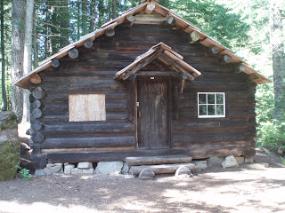
| Old guard station |
 |
| Guard station is old!!! |
 |
| Take a walk across bridge near Lake @ Dennis Long |
 | ||
| Zoom view Johnson @ Dennis Long
|
Driving directions: From Packwood, follow U.S. Highway 12 to the east end of town and turn south-east onto Forest Road 1262 and continue for 6 miles to the trailhead parking lot. You can always call the Gifford Pinchot National Forest Randle office for road updates 360-497-1100
Trail stats: Roundtrip 10 miles with 600 foot gain and high point of 3200 feet. Please take map-compass-GPS as the trail information is out best estimate.
Custom Weather Forecasts Services
 |
| Click to check out our forensic & custom weather services |

No comments:
Post a Comment