Updated May 29, 2012
Iron Creek to Teanaway Ridge (aka Iron-Bear trail) is a great spring hike with lots of flowers now. Patchy snow close to 5000 feet.
Photo below is view of Stuart Range from snowfree knob, photo by Alan Bauer
Most photos and trail updates from Kim Brown. Thanks Kim
Photo below is view of the Stuart Range and other snow covered peaks
 Check out Green Trails Maps for directions. Map for this week's trip is 210. Click link below for complete list of maps.
http://
http://greentrailsmaps.com/maps/index_Map_wa/
Photo below is hiking in the forest
Photo below is of balsamroot flowers
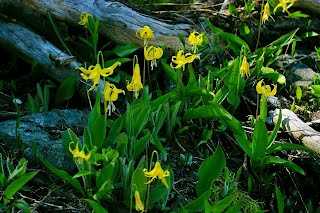
Photo below is of glacier lilies
flowers
Photo below is the open views you get in the East Cascades
Driving directions: Drive east on Interstate 90 to US 97. About two miles north of Mineral Springs, look for Forest Service Road No. 9714 (Iron Creek Road) going off to the left (west). Continue about 3.5 miles to road's end and the trailhead and parking at 3,800 feet.
Trail stats: From the trailhead to the high point (5489 feet) is about 6.4 miles round trip.
Directions and trail stats are our best estimate however please have a good local map and or a GPS unit.
Custom Weather Forecasts & Services


No comments:
Post a Comment