Map above is the 300 mb chart (location of jet stream) for the forecast period ending Sunday night 12-28. Notice the strong winds of about 150 miles per hour at the 30,000 foot level. These strong winds are westerly winds that bring mild moisture in from the Pacific. This west flow is the more typical pattern that we experience of precipitation on and off, freezing levels close to 3000 to 5000 feet. However, we are not expecting the excessively wet and warm (freezing levels close to 10,000 feet) "pineapple express."
With the snow on the ground and warmer temperatures along with rain this might generate some interesting stormwater flows.
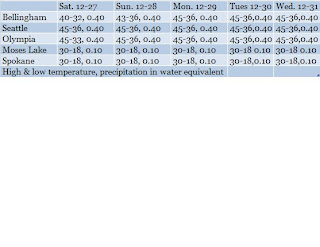
This pattern should continue through the end of the year. Then starting January 3, 2009 or so another shot of colder air moves in, however, that is indeed in the extended forecast period so limited confidence. However, if this colder pattern occurs it will not be as cold as this modified arctic air that has been over the region since the middle of December.
Finally we have listed below the forecast for the period this Saturday 12-27 to Wednesday 12-31.

No comments:
Post a Comment