
Wednesday, May 30, 2012
Washington Cascades Weather Outlook
Issued May 30, 2012
Forecast models indicate that the weather patterns through June 12 will feature below normal temperatures and above normal precipitation. The main reason for this is there will be a trough of low pressure that is off the Washington Coast for much of this period. The 500 mb maps below (18,000 feet) confirms this pattern.

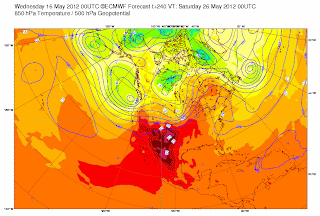
Wednesday, May 16, 2012
Extended Outlook Cascades
Issued: May 16, 2016
Forecast models are starting to suggest that the weather patterns for the Washington Cascades change especially for the period of May 23 to May 29 as temperatures will be below normal and precipitation above normal. The 500 mb map (at 18,000 feet) below confirms that pattern as the map below indicates a trough of low pressure off Northwest coast.

Monday, May 14, 2012
KUOW Hike- Sauer Mountain
Update Tuesday May 15, 2012
Sauer Mountain east of Leavenworth. Snowfree hike with lots of wildflowers and great views.
All photos by Alan Bauer
Photo below is view of Enchantments from the top


Check out Green Trails Maps for directions. Map for this week's trip is 178. Click link below for complete list of maps.http:// http://greentrailsmaps.com/maps/index_Map_wa/
Photo below is many of the Balsam Root
 Photo below is Ponderosa Pine Tree
 Photo below is one of the many flowers, Oregon Anemone


Check out Green Trails Maps for directions. Map for this week's trip is 178. Click link below for complete list of maps.http:// http://greentrailsmaps.com/maps/index_Map_wa/
Photo below is many of the Balsam Root


Driving Direction: Drive Highway 2 to milepost 103.7 (three miles east of Leavenworth). At the traffic light leading into Peshastin, turn onto Main Street and cross the Wenatchee River on the old concrete bridge. Stay on the main road as it jogs and after about 0.3 mile go under the railroad tracks and take an immediate left turn. Drive through Peshastin on what will become North Road. In about a mile (after the Icicle Ridge Winery and just before the cemetery), turn right on Anderson Canyon Road and drive uphill. At a fork in the road, stay left and keep going a short distance until the county road ends (about 0.6 miles from North Road). The trailhead is at the end of the road. Pleas note that the trail is closed from October 14 to March 21.
Map of trail thanks to Wenatchee Outdoors for some of the trail and map content http://www.justgetout.net/Wenatchee/14485
Trail stats: Roundtrip distance is roughly 5.5 miles top is 3110 feet and 1800 foot gain. No permits are needed this starts on private property so please respect that.
Directions are the best estimates that we have so please bring map and compass and or GPS.

Custom Weather Forecasts & Services
West Coast WeatherContact us
Wednesday, May 9, 2012
Extended Outlook Cascades
Issued May 9, 2012
Forecast models for the period May 15 to May 22 are indicating above normal temperatures and below normal precipitation.
Forecast models for the period May 15 to May 22 are indicating above normal temperatures and below normal precipitation.
Wednesday, May 2, 2012
Extended forecast Washington Cascades
Issued May 2,2012
Forecast models out to May 12, 2012 are indicating above normal temperatures and below normal precipitation. However if the forecast map below verifies this would bring above normal precipitation and normal to above normal temperatures. The map below 500 mb (18,000 feet) which indicates a trough of low pressure to west of Washington


Subscribe to:
Posts (Atom)