Thursday, April 27, 2017

Fagin's Hike of the Week: Mt. McDonald

Updated: April 28, 2017

Hike near Kent, Mt. McDonald or on some maps Point McDonald. The last 200 feet have hardpacked snow but that should melt out soon.


View of Olympic Mountains  from the top
View of the Olympic Mountains from the top
View of Mt. Rainier on spur Road just below the summit


Road walk
Coltsfoot @ Tony Long


Driving directions: From junction of Highway 18 and and Highway 169 take Highway 169 (Maple valley Highway) south 2.7 miles to Kent-Kangley Road and turn left (east). Then go 6.7 miles on this road. Then park on right next to Blue DNR gated road (do not block gate) and park here. Sign will say: SE Kent-Kangley Road and 346th SE.

Trail stats: 4.1 3 miles one way elevation gain is about 2500 feet and top is at 3300 feet. Follow main road to the top.
Park car near here

Park near this gate this is where you start


We took the area marked "gate" the north most entrance and hiked to "radio tower."
Directions are the best estimates that we have so please bring map and compass and or GPS.


 Custom Weather  Services from Weather Experts


Click to check out our forensic & custom weather services
Email us West Coast Weather Contact us

Wednesday, April 26, 2017

Weather Washington Cascades- Extended Outlook

Issued April 26, 2017

Starting next week models are suggesting that a strong ridge of high pressure builds by May 3 so we should get several days of mild and dry conditions. Too much uncertainty to know if this ridge remains in place that many days beyond May 3.

500 mb map (18,000') for May 3

Custom Weather  Services from Weather Experts
Providing these services: Custom forecasts from the Washington Cascades, to Mt. Everest. Not for the mountains we can do it an upcoming wedding. We are also provide forensic meteorological services as expert witness in court. 


Click to check out our forensic & custom weather services


Thursday, April 20, 2017

Fagin's Hike of the Week- Bessemer Mt

Updated 1 April 20, 2017
This trailhead is near North Bend Washington. It is a logging road walk that takes you up to saddle at about 4100 feet. This offers great views. If you want to go to the summit that is another 1.2 miles or so and another 1100' and you need to access any possible avalanche issues. Snowshoes are needed at about 3000'.


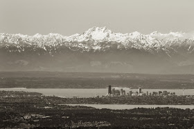
View from the top of Olympics @ Gerrit Saylor 
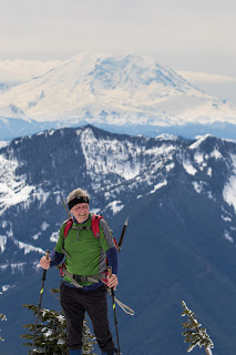
View from the top George and Mt Rainier @ Gerrit Saylor
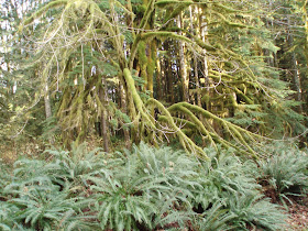
Lower part trail  lots of moss @ Michael Fagin

Waterfalls on the way up

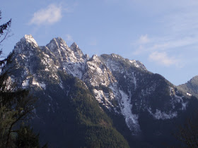
View of Russian Buttes at the saddle @ Michael Fagin
Driving Directions: From Seattle, drive east on I-90 to exit 34 and turn left (north) onto 468th Street and follow it to the junction with the Middle Fork Snoqualmie Road (Forest Road 56). Turn right and continue up the Middle Fork Snoqualmie Road for 7.4 miles park at gated road on the left. Gate is marked "905 " and it is blue. You need discovery pass as this is state land DNR.
Trail Stats: About 3000 foot gain high point is 4100 feet. About 10 miles roundtrip. Start on logging road and walk about a mile and then turn right on logging road, going left takes you on an old hiking trail which you do not want. Basically continue to follow logging road and follow it uphill until you reach saddle at about 4100 feet. Do not go to the summit, safe that for the summer. Saddle at Location GPS way points
Latitude: 47.545972º N
Longitude: 121.618268º W
Altitude: 4,077 ft
Thanks George for GPS waypoints.


Please bring map and compass and or GPS as these directions are just estimates.
Hike for MPF

Wednesday, April 19, 2017

Weather Washington Cascades- Extended Outlook

Issued 4-19-2017

We will continue the pattern of troughs of low pressure that drop down from the Gulf of Alaska and this will be the pattern through the end of April. Thus we will continue with below normal temperatures and above normal precipitation. However keep in mind that there will be some dry periods, like this Friday.

500 mb (18,000')


Custom Weather  Services from Weather Experts
Providing these services: Custom forecasts from the Washington Cascades, to Mt. Everest. Not for the mountains we can do it an upcoming wedding. We are also provide forensic meteorological services as expert witness in court. Forecasts for as little as $25


Click to check out our forensic & custom weather services
Email us West Coast Weather Contact us


Wednesday, April 12, 2017

Washington Cascades Weather: Extended Outlook

Issued: April 12, 2017

We continue the pattern of having troughs of low pressure that drop down from the Gulf of Alaska and this should be the pattern through April 25. This pattern will bring below normal temperatures and above normal precipitation. However we will have some dry and mild periods like this coming weekend.

500 mb (18,000') trough of our coast


Custom Weather  Services from Weather Experts
Providing these services: Custom forecasts from the Washington Cascades, to Mt. Everest. Not for the mountains we can do it an upcoming wedding. We are also provide forensic meteorological services as expert witness in court.  Custom forecasts for as little as $25.00


Wednesday, April 5, 2017

Fagin's Hike of the Week- Ancient Lakes

Updated 4-5-2017

The flower picture was  taken from last year and I was just out there and the flowers are several weeks behind the schedule from last year.
View of Dusty Lake from the rim above @ Alan Bauer
On the way to the lake passing a glacial erratic (aka big rock) @ Alan Bauer
Desert Shooting Star @ Alan Bauer
View of waterfalls and lake @ Alan Bauer
Ancient Lakes @ Dennis Long
Columns of basalt @ Michael Fagin
Some off trail scrambling @ Dennis Long
Columbia River @ Michael Fagin
Driving directions: Drive I-90 east to exit 149, SR 281. Go north towards Quincy. After 5.6 miles turn left on White Trail Road, and follow that 7.8 miles to road 9-NW. Continue 5.9 miles on this road and park in  at the end of the road.

Trail stats: Our loop was about 7 miles roundtrip with evelvation gain is minimal.
Our hike was along the valley to  the lake then back along south rim


 Disclaimer: There are many factors which you should consider in deciding whether to proceed with an outing, including the visible weather at the trailhead, the strength and experience of the party, snow and avalanche conditions, route conditions, etc. You are the final decision maker whether to proceed. West Coast Weather, LLC dba Washington Online Weather cannot be held liable for loss or injury arising from your decision to proceed, and expressly disclaims all liability related thereto. Redmond, Washington USA. Also, please bring map-compass and GPS to help with trail directions as our directions are our best estimate.

Custom Weather  Services from Weather Experts
Providing these services: Custom forecasts from the Washington Cascades, to Mt. Everest. Not for the mountains we can do it an upcoming wedding. We are also provide forensic meteorological services as expert witness in court. 


Click to check out our forensic & custom weather services
Email us West Coast Weather Contact us


Washington Cascades Weather: Extended Outlook

Issued April 5, 2017

The extended forecast through April 18 continues with above normal precipitation and below normal temperatures . The main reason for this pattern is we will continue having troughs of low pressure that drop down from the Gulf of Alaska.

Trough of low pressure off our coast again 500 mb map at 18,000'

Custom Weather  Services from Weather Experts


Click to check out our forensic & custom weather services
Email us West Coast Weather Contact us